Tract Biloberezha
Nicholas Zharkikh
The first document that the area Biloberezha was given in possession of the St. Nicholas monastery, was signed by Cherkasy headman O. Dashkovich [Archive South-West Russia. – Kyiv: 1890, part 7, Vol. 2, № 4, p. 11]. He was at this position in the 1508 – 1535, so charter should be dated this time. Landmarks that are specified in this charter, now do not exist, but the area can be defined on the basis of more recent documents.
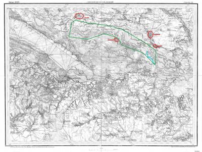
Location of Biloberezha recorded in the Universal Hetman Bohdan Khmelnytsky 11 (21) March 1649 for St. Nicholas Monastery (Universals Bohdan Khmelnytsky. – Kyiv: 1998, № 24, p. 90), " starting at Beloberezhja until lake called Dubok, but only border here Gorodische and Maksymovka". On those same places referred to in the universal number 56 on March 30 (April 9) 1652.
Sheet of the of 1868
with the designation of Bogdan Khmelnytsky's grant
On the map in red underlined settlements, which are referred to, blue – river Dubok (right channel Dnieper), green – assumed border of lands in the floodplain of the Dnieper granted to St. Nicholas Monastery.
For our topic is important that the distance from Moshny to Gradyzk quite large (106 km), and one can not insist on the identity of this Biloberezha and Bil-bereg.
It is an abstract of the chapter. For the full text see please ukrainian version.

