Consequences of the attack
Nicholas Zharkikh
The reconstruction of the Kyiv castle is reported by Jan of Targowica and a note for King Sigismund.
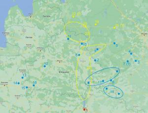
The statement of the mobilization plan in the note also contains something interesting, especially if you look at the map:
Map of the mobilization district of 1483
The map shows:
1 – Kyiv (and further distances from it)
Blue circles – troop mobilization centers:
2 – Mstislavl (400 km)
3 – Odoiv (570 km)
4 – Vorotynsk (580)
5 – Vyazma (580 km)
6 – Trubchevsk (320 km)
7 – Kozelsk (530 km)
8 – Drutsk (430 km)
9 – Smolensk (490 km)
10 – Vitebsk (530 km)
11 – Polotsk (570 km)
12 – Novogrudok (470 km)
13 – Bielsk-Podlaski (570 km)
14 – Dorogichin (590 km)
15 – Brest (500 km)
16 – Kobrin (470 km)
17 – Starodub (280 km), Gomel (220 km), Bryansk (410 km) – possession of Prince Mozhaisky
18 – Novgorod-Siversky (260 km), Rylsk (315 km) – possession of Prince Shemyatych
Yellow circles – centers for mobilization of workers:
19 – Toropets (670 km)
20 – Velikiye Luki (650 km)
21 – Velyka Rzheva 1 (? Tver region, 690 km)
22 – Velyka Rzheva 2 (? Pskov region, 730 km)
23 – Trans-Dvina parishes
24 – Dnieper parishes
Shortened text of the section. Full text in ukrainian version.

