Terekhtemyriv on maps of 17 – 18 cent.
Nicholas Zharkikh
Learning special issue – displaying Terekhtemyriv on the maps – allowed to come to broader conclusions about mapping the entire Dnieper:

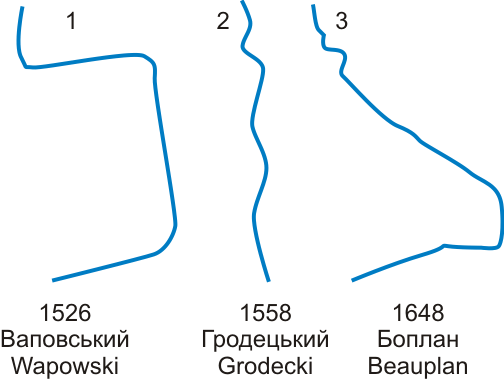
Three traditions of the Dnieper images on the 16 – 17-cent. maps
1. Displaying of Dnieper on the 16 – 18-cent. maps passed three stages, each characterized by own contour of Dnieper:
1.1. Tradition of B.Wapowski's map (1526) – generally on the Dnieper noted only Kyiv, Kaniv (sometimes) and Cherkassy. This tradition was dominant in the 16th century and becomes 17 cent.
1.2. Tradition of V.Grodecki's map (1558) – initially differs from Wapowski's one only an outline of the Dnieper. The map by T.Makowski – N. Radziwill (1613) was drawn in this tradition, but replenished with a lot of new objects over Dnieper, particularly – Terekhtemyriv in characteristic pleophonic form. Bright noticeable feature for maps of this tradition is false images of Terekhtemyriv monastery much lower Cherkasy, at the mouth Tyasmyn. Maps of this tradition were published until the end of 17th century.
1.3. Tradition of G. Beauplan's map (1648), which presents a realistic outline of the great grasslands of the Dnieper and many objects on the Dnieper. These objects are given regardless of the Makowski's map; characteristic feature is the name of Terekhtemyriv in non-pleophonic and somewhat distorted form (Trethymirow). Terekhtemyriv monastery presented in its proper place – slightly below Terekhtemyriv. Maps of this tradition became popular in the 2 half 17th century, and in 18 cent. completely replaced the maps of other traditions.
2. Terekhtemyriv can be seen in almost all general maps, which shows the middle Dnieper: the map of Ukraine, the Grand Duchy of Lithuania, the Polish-Lithuanian Commonwealth, the European part of the Russian Empire, Taurica (or Little Tartary), maps of the Dnieper. This indicates a significant weight afforded to this item by cartographers 17 – 18 cent.
3. In the 19th century. Terekhtemyriv disappears from the general maps and displayed only on large-scale maps of the Kyiv region, indicating a decrease in its value at this time.
4. 17-cent. maps can unequivocally state that Terekhtemyriv monastery located in the modern village Monastyrok, but not in the Terekhtemyriv that depicted separately upstream of the monastery.
