Peace of 1508
Nicholas Zharkikh
Shortened text of the section. Full text in ukrainian version.
The war between Moscow and the Great Duchy of Lithuania in 1507 – 1508 was ended by a peace treaty concluded on October 8, 1508. I briefly consider the political circumstances of its conclusion in another place of my work, and here I want to consider the geography of the border established by this treaty.
Although the text of the agreement does not directly mention the action of M. L. Glynsky, the strip of settlements on both sides of the border shows us the claims of the parties that were settled (as it turned out, for a very short time!).
The agreement has reached us in the form of a chart of the Moscow Grand Duke Vasyl III, twice entered in the Lithuanian metric [LM 7, No. 55, – 141 = LM 8, No. 80, – 128]. I quote the text mainly from the 7th book, and the different readings of geographical names are added from the 8th book.
The agreement can be divided into three parts: 1, general political conditions; 2, description of the border; 3, special conditions (which I will not quote here). In the comments, I write "I can’t guess" when I searched for an object and did not find it; I write "maybe" when I found a match for the name, but there is no confirmation on Wikipedia.
A table (230 lines) with considerations regarding the placement of the names listed in the chart (text in the Ukrainian version).
Further in the text of the chart are special articles, which I do not consider.
The chart on which the search results are summarized looks like this:
(Perhaps it will be more convenient for you to view this map scheme in a separate window: . I worked on it from June 22 to 29, 2023. In Russia during this time, the Prigozhin rebellion had time to start and end, and I was sitting on the same map all the time.)

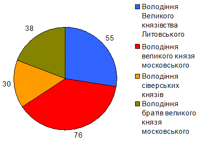
Geographic distribution of objects by affiliation
It should be noted that the contract was drawn up carelessly, without proper editing. And so it turned out that Roslavl and Mstislavl are listed both in the Lithuanian list and in the Moscow one. Apparently, the clarification of these territorial problems could delay the negotiations, or even disrupt them altogether, and the parties, it seems, were in a hurry to conclude at least some kind of agreement.
The list from the Moscow side consists of four structural parts, while in the part "possessions of the Seversky princes" a group of settlements around Gomel is clearly distinguished (No. 16 – 28). It can be thought that this group was the subject of a separate border dispute, and its protocol was used in the treaty.
What does this map scheme provide for my narrow topic – the history of the Glynski princes?
1, on the map we see on the Lithuanian side a strip 180..230 km wide, into which Moscow should not "enter". I think this is a territory that could fall away from Lithuania if Glynsky’s action is successful.
2, a similar but significantly wider strip (from 200 km near Toropets to 350 km in Severshchyna) on the side of Moscow shows its gains in the wars against Lithuania. Moscow still did not consider these gains final and insisted on the recognition of these conquests by Lithuania.
3, the map shows a wedge of no-man’s land in the southern parts of modern Chernihiv and Sumy regions. The outermost Lithuanian (and from 1500 – Muscovite) town in the south was Putivl, and further to the south – southeast, the demarcation did not continue. Both sides saw it as a no-man’s Wilderness, with nothing to share.
The upper flow of Sula, and even more so Vorskla, on which two villages named Glynsk are located, were not included in the sphere of state interests of the Grand Duchies of Lithuania and Moscow at that time. These were uninhabited wastelands. Their colonization belongs to the time when the Glynski princes had already left the historical scene.
