
Kazakhstan
Nicholas Zharkikh
Information about the trip through Kazakhstan and Central Asia (Ch. 23 – 25) require more detailed consideration because, in my opinion, comments are not entirely correct. For convenience of reference divide the Rubruk's text into smaller fragments and number them:
[1] So we rode through the country of the Cangle from the feast of the Holy Cross to the feast of All Saints, and nearly every day we went, as well as I could estimate, about the distance from Paris to Orleans, and sometimes more, according to the supply of horses
Starting from the river Yaik, travelers moved eastward within 33 days (29.09 – 30.10.1253). I assume that this path was somewhere between 48 th and 49 th parallels. Had they really been traveling daily distance from Paris to Orleans (135 km), then covered for 33 days to 4.5 thousand km, and would find themselves somewhere on the river Kherlen in Mongolia. Note to the 1957 edition says that Rubruk drove 80..100 km per day. This is clearly less than the distance Paris – Orleans, but still a lot of (3300 km from Yaik – will be area of Lake Khara-Nur in the west of Mongolia). Based on the rate of 40 km per day, they would drive 1320 km and find themselves somewhere near the modern town Kyzylzhar (which lies at the railroad Karaganda – Dzhezkazgan). But if we turn to the south here, we would even lying plain. So I had to make a small stretch and continue road to east for another 150 km to the town Atasu at mentioned railroads (average speed will be 44 km a day).
[2] The eve of All Saints we left the road to the east, for the people had already moved a good deal to the south, and we made our way by some alps due south continually for eight days.
"Some alps" is an important landmark for us, because it can be easy identifying with Upytau mountains (they are south-western part of the Kazakh uplands). The highest mountain is called Akmeshyt and has the absolute height of 1133 m. That is the way to the south was approximately the 72nd meridian east longitude.
[3] The seventh day we began to see to the south some very high mountains, and we entered a plain irrigated like a garden, and here we found cultivated land.
Very high mountains in the south is the Tien Shan. From what distance one can see them? A simple exercise in trigonometry gives us the formula:
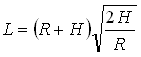
where R – radius of the Earth; H – the excess of the mountain above the point of observation, L – the distance from which you can see the mountain. Taking the mountain height about 4,000 m and height of the observation point 500 m, we obtain a distance about 200 km.
This condition corresponds (with a specific stretch) to village Birlyk on Chu river (Moyynkum district, Zhambyl region in Kazakhstan), remote from the mountains for 180 km. Stretch is that the geometric opportunity to pave a straight line between the point of observation and the object is only a necessary but not sufficient condition. The presence of dust, mist, play of ascending and descending flows in the atmosphere and many other factors causing light scattering and absorption, limiting the zone of visibility. Of course, the most convincing result can be obtained experimentally, while somebody passed across the steppe and observe when Tien Shan becomes visible…
[4] On the octave of All Saints we entered a certain town of Saracens called Kinchat […] I inquired the name of this province; but as we had already passed into another territory, they were unable to tell me anything beyond the name of the town, which was a very small one.
N.P. Shastina writes: "Probably Kenjek town in the valley of Talas". The name "Kenjek" is also adopted in English translation. Search for a town Kenjek showed that this name is found in the sources, but localize it still failed. So it's – just visibility of comment when one unknown is given instead of second, just unknown.
[5] And there came a big river down from the mountains, which irrigated the whole country wherever they wanted to lead the water, and it flowed not into any sea, but was absorbed in the ground, forming many marshes.
N.P. Shastina writes: "This is river Talas". This should be noted that Rubruk was driving from the north and to get Talas had to cross the river Chu, which satisfies all the requirements of Rubruk's description not worse than the Talas: flowing from the mountains, creates a lot of wetlands, is a source of irrigation and lost in the sands. So I think that a great river in this episode – a river Chu and the town Kinchat located on its right bank somewhere near the village Birlyk. There is no wonder it has not yet localized, since Rubruk noted that the town was very small.
Another stretch that we have to do – is the distance between Atasu and Birlyk, which is over 500 km. We must assume: 1st, that on the road to the south travelers increased speed to 60.. 65 km per day; or 2nd, move the point of turning to the south (No 2) somewhere south of Atasu and thus reduce this shoulder of route.
[6] The next day we came to another village nearer the mountains
I assume the travelers moved alone Chu river same bank to the southeast and stopped somewhere opposite the modern town Chu (Shu), which lies on the left bank.
[7] and I inquired concerning these mountains, which I understood to be those of the Caucasus, which confine at either extremity on the sea, from the west to the east
It is a pity that Rubruk not recorded the original names of these mountains. Name of the Caucasus is the result of Rubruk's geographical considerations: Tien Shan mountains stretching from west to east as well as real Caucasus, which direction was known to Rubruk.
[8] we had already crossed at the sea previously mentioned into which the Etilia flows.
Although Rubruk here clearly indicates the Caspian Sea, its leaders, when they were asked about the sea, could be kept in mind the Aral Sea, not mentioned by Rubruk.
[9] I asked also concerning the town of Talas in which were Teuton slaves of Buri […] As to those Teutons I was unable to learn anything concerning them all the way to Mangu Chan's ordu, but in the village just referred to I gathered that Talas was beyond us in the direction of the mountains, 6 days' travel.
Talas town is well known. Today it is called Taraz and is located in the south Kazakhstan (not to be confused with the Ukrainian town Talas, in Kyrgyzstan which is above the river and founded in 1877). Talas lies 220 km southwest of Rubruk's breakpoint calculated by me. This is the classic six days' journey. Since Rubruk moving general course to the east, the direction of the south-west really was for him the way back.
This episode further reveals that river with the episode number 5 could not be Talas. If Rubruk rode along the Talas, the Talas town would be ahead of him or on the right hand, but not behind.
[10] When I reached the ordu of Mangu Chan I gathered that Mangu had transported these Teutons, with Baatu's permission, the distance of a month's travel to the east of Talas, to a certain town called Bolat, where they are digging for gold and manufacturing arms, so I could neither go nor come back their way. However, in going I passed quite near that town [of Bolat], perhaps three days from it, but I was unaware of it, nor could I have turned from my route if I had known it.
N.P. Shastina gives this note: "Medieval Iranian authors call it Pulad or Pula". Which authors were in mind – I could not define, so I did not find the instructions on the location of this Bolat – Pulad – Pula.
Assuming that month the way is 900 km and putting this distance east of Talas, we get into the area where the rivers Kunhes and Tekes flow together, forming a river Ili. The key is mention that the Germans had mined gold. Indeed, in this area is a deposit of gold Axi (its coordinates – 43 ° 30 ' north Latitude, 81 ° east longitude; this is a north slope of Ketmen ridge, overlooking the valley of the river Ili). This place located for 125 km west of the beginning of the river Ili, or 775 km east of Talas. City Ghulja (Yining) lies from it to the north, about 50..60 km, ie Rubruk when urged to Ghulja, really was in two days the road from this place.
Such an amazing coincidence all the instructions can not be accidental, so I assume that the town Bolat was located near this Axi deposit.
[11] From the village I have mentioned we went eastward, close to the mountains above referred to, and from that point we entered among the subjects of Mangu Chan.
In my opinion, it ranges Zheltau (north) and Aytau (south), which form the watershed between the river Chu and lake Balkhash. They, as we see, had meaning and clearly defined areas of the administrative border. The Rubruk's route led through Aytau.
[12] A few days later we entered the alps in which the Caracatai used to live,
It generally refers to the northern slopes of the Tien Shan.
[13] and there we found a great river which we had to pass in a boat.
This, of course, the river Ili – the largest of the rivers in Zhetysu region. If we assume that travelers crossed through Ili not where they drew near to it (perhaps not at every step can be found boats for crossing), they had a further way to the east left (south) bank of the Ili.

|
Rubruk's route through southern Kazakhstan Designated by numbers: 1 – place of town Kinchat assumed by N.P.Shastina; 2 – ancient city Talas (modern Taraz); 3 – place of town Equius assumed by A.I.Malein; 4 – place of city Cailac assumed by A.I.Malein; 5 – modern town Kopal; 6 – modern village Birlyk – town Kinchat assumed by N.I.Zharkikh; 7 – modern town Chu (Shu); 8 – place of town Equius assumed by N.I.Zharkikh; 9 – modern deposit Axi – town Bolat assumed by N.I.Zharkikh; 10 – ancient city Ghulja (modern Yining). |
[14] After that we entered a valley, where we saw a ruined fort, whose walls were nothing but mud, and the soil was cultivated there.
[15] And after that we found a goodly town, called Equius, in which were Saracens speaking Persian, though they were a very long way off from Persia.
A. Malein to this place gave a note: "Equius situated near present Kopal; exact place is unknown". What he had grounds for such a location as for the localization of Cailac (№ 20, near present Kopal as well) – I do not know. But it is clear from these locations – Rubruk's route (as imagined Malein) followed by Zhetysu region, having lake Balkhash (№ 18) at north, and Dzungarian Alatau ridge (№ 17) in the south. In comments to the subsequent (29th) chapter mentions lake Alakol and Tarbagatai ridge. Summarizing, we can say that according to commentators Rubruk rounded Dzungarian Alatau from the north.
Is all Rubruk's notes consistent with this route? In my opinion, they also comply the southern route – along the Ili River, south of Dzungarian Alatau.
So, assuming south route (№ 13), the fort ruins (14) and the town Equius (15) will be found on the left bank of the Ili.
[16] The next day, having crossed these alps which project from the high mountains in the south,
South of river Ili extend from west to east Trans-Ili Alatau and Ketmen ridges.
[17] we entered a beautiful plain with high mountains to the right,
[18] and a sea or lake which is twenty-five days in circumference to the left. And all this plain is well watered by the streams which come down from the mountains, and all of which flow into this sea.
Lake, located to the left – is certainly Balkhash, whose dimensions are given surprisingly accurate (its length about 525 km, ie the need to detour around 1100 km, and 25 days' journey – a 750..1000 km). In the high mountains to the right (south) is traditionally understood Dzungarian Alatau ridge and, thus, this whole passage refers to the description of Zhetysu region – the territory between the Balkhash and Dzungarian Alatau. But the Rubruk's description not so detailed that one could not stretch it also over r.Ili valley and add Trans-Ili Alatau to high mountains to the right.
[19] In the summer time we came back along the north shore of this sea, and there likewise were great mountains.
There are no high mountains directly north of the Balkhash, I think there Rubruk meant Tarbagatai mountains, really high (at 3000 m), which is located northeast of Balkhash.
[20] We found there a big town called Cailac, where there was a market, and many traders frequented it. Here we rested twelve days.
A. Malein to this place gave a note: "Cailac was a little west of modern Kopal".
[21] This country used to be called Organum, and the people used to have a language and letters of their own; but now it is all occupied by Turkomans.
For this item N.P. Shastina gave the following explanation:
"Organum was Almalyk or Ghulja. Organa was the name of the queen of country, so here Rubruk wrong. Organa was the widow of Kara Hulagu, grandson of Chagatai, and ruled after the death of her husband to his ulus. Rubruk moved queen's own name on the area name, where she rules".
Direct path from Kopal to Ghulja is 250 km, while necessary to cross two fairly decent mountain ridges – Dzungarian Alatau and Bedzhyntau. If travelers were going to drive through Ghulja (I think so), then before them was quite profitable way up the valley of the Ili River. Even worse is that after leaving the Cailac route (as comments) came near Alakol lake (which is 250 km north – again through Borohoro and Dzungarian Alatau ridges). Thus, N.P. Shastina expressed interesting speculation that Rubruk drove through Ghulja, but this assumption is contrary to northern route of Rubruk, proposed by Malein and adopted in other comments.
But if the geographical assumption by N.P. Shastina can be adopted, the historical explanation is grounless. Organa in her comment was Ergene-Khatun, the widow of Khara-Hulagu (son of Mutugen, the grandson of Chagatai). But Khara-Hulagu ruled in this area in 1242 – 1247 and 1252; after his death Ergene became regent at his minor son Mubarek Shah. The time of her reign coincides precisely with the time of Rubruk's travel, and nobody can explain why this name referred to last time. Second weakness is that Rubruk did not mention any queen, although during 12 days of the staying in Cailac he have time to make visit to her. The third contradiction: Rubruk clearly says (№ 11), they were among Möngke's people, and he said no realm of descendants of Chagatai. Rubruk said Ken Khan court (ie Güyük, wider – ulus Ogedei headquarters), but have not heard about the Chagatai court.
So we can safely reject the assumption that the geographical name Organum connected with the name of the queen Ergene.
W.Rockhill in his English translation suggests that the Organum means Urgench (of course, not the city, but all Central Asia or Sogdiana), and ancient writings means sogdian ones. This assumption may be accepted: Nestorian texts in sogdian language and writing really known, and the decline of this language occurred somewhere in the 11th century (ie at times Rubruk it was already quite respectable antiquity).
Harder is the case of great city Cailac. Researchers who commented this item or repeat verbatim Malein's assumption (without its explanation or justification), or point out that this city is not localized. But I find it hard to believe that a great city disappeared without a trace. At the same time there are not known significant ancient cities on the northern path.
In my opinion, Rubruk's Cailac is a modern Ghulja, an ancient city in the upper reaches of the river Ili. Ghulja lies on the right bank of the Ili, and on the left bank opposite marked the town Kaynak (so on the Soviet map of 1967, on a modern Google map – Qapqal). Do not know from what time comes this toponym, but perhaps it may mean something, because very similar to the one recorded by Rubruk.
There is a point that makes me wary of the southern route – a distance between Kinchat and Cailac – 650 km, which gives the rate of motion of 72 km per day. But this rate, how soon shall see, is not impossible.